
US and World Desk Map (13″ x 18″ Laminated) for Students, Home or Classroom Use by Lighthouse Geographics
$9.95
Related Products

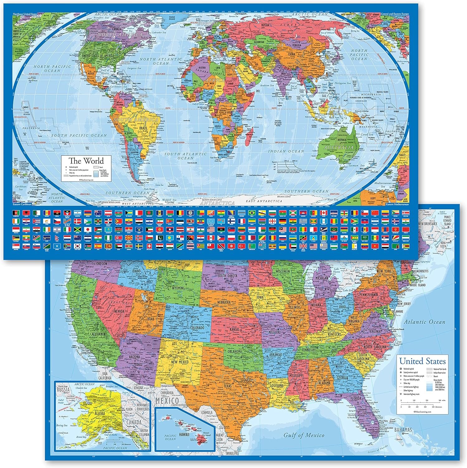


This laminated double-sided desk reference map features two maps in one. One side features an attractive, political map of the United States in lively, pastel colors while the flip side reveals an equally attractive current world map. The United states map shows major cities, time zones and all of the fifty state capitals are highlighted in red. The world map presents the nations of the world with an abundance of clear, concise and current geographical information
TWO-SIDED MAP: One side features an attractive, political map of the United States in lively, pastel colors while the flip side reveals an equally attractive world map, providing accessible and functional use.
UNITED STATES MAP: The United states map shows the clearly delineated fifty states (with Hawaii and Alaska as inserts), major cities, time zones and all state capitals marked in red stars.
WORLD MAP: The world map presents nations of the world with an abundance of clear, concise and current geographical information. The Europe-inserted map provides a zoomed in map of Europe with a larger scale to clearly show this congested part of the world.
MULTIPLE USES: The maps are an excellent reference source for home, office, and classroom uses. Students in all grades, teachers, and general adults could all benefit from the concise and clear presentation of US and World geographies.
DURABLE THICK LAMINATION: The 5-mil double sided lamination provides protection and durability. DIMENSIONS: The exact dimensions are: 12-3/4″ x 17-3/4″. MADE in USA: The designs, printing, and lamination are all done in the United States by American Geographics.
8 reviews for US and World Desk Map (13″ x 18″ Laminated) for Students, Home or Classroom Use by Lighthouse Geographics
Add a review
$9.95
Janee56 –
Such a good size map and detailed
I got tired of trying of looking at a map of the USA on my phone to show my young grandkids so decided to give this map a try. It is perfect! The size and details are wonderful. It is exciting to the grandkids to point out the states when they can see them in a large size. One side is the USA and the other side is the World. Laminated and high quality.
Antoinette Harris –
LIKE THESE
Just got ours today for our students and I really like the quality. They are double-sided and laminated which is awesome. We plan to use them for teaching longitude and latitude and I tried out one of the coordinates to check to make sure it was accurate, it was. I’m excited to use these and likely will order more in the future!
Jillian –
Homeschool family
This is the perfect size for sitting on the table while homeschooling. We readily keep it out smooth reference while schooling. So much easier than running to the wall to look each time. It’s not a super zoomed in view but we keep larger wall maps for those situations. Good price. Bright colors. Laminated and thick which makes it durable. It’s a great tool for teaching kids.
Valkyrie –
Nice, but arrived with creases due to handling in postal system. 🙁
This is a nice map, and is easy to read. Unfortunately it arrived with creases because it was put into a thin envelope and sent through USPS, where it was folded up to get put into our mailbox. It should have been packaged with some sturdy cardboard and marked Do Not Fold.
Elaine –
Study time here we come!!
He really liked it and kept saying the States, and was anxious to use it.
D Williamson –
Bright, sturdy and provides good information.
Had been using a small 5×7 foldable map for referencing geographic locations mentioned in books and news articles. Map was not current so finally upgraded. This one is roughly the size of a placemat and not foldable so while not as convenient it’s bright, nice lamination, easy to read and reflects a lot of updated information so very pleased. Will likely buy a few for Toys for Tots drive next year.
Michael B. –
Well Made With Just Enough Detail
Love this map as it is easy to read with clear font. There is just enough detail to clearly identify certain US cities and (on the flip side) many countries. The map is true to size and the lamination is perfect protecting both sides of the map.
qpham63 –
Good value and tool to teach your children about the world.
Our family of 4 is a globe trotting family with 2-3 vacations each year and mostly traveling abroad. This is a great tool along with a globe to show our 9 years old daughter where we have been and we we will be going. Antarctica is a bit stretched out and made too big but what happens when you flatten out a sphere. Along with the globe it is easy to explain to my daughter the scale of things and how they distorts when flatten out to a 2D map.This along with our travel has really piqued her interest in international affairs as well as the history of each place we were and where we will be going. She likes to read up on our vacation destination before we go even going as far as practicing hello, thank you and other useful words in the native languages.