
Rand McNally Road Atlas Large Scale 2026: United States, Canada, Mexico (Rand McNally Large Scale Road Atlas USA)
$30.75
Related Products


Rand McNally 2026 Large Scale Road Atlas
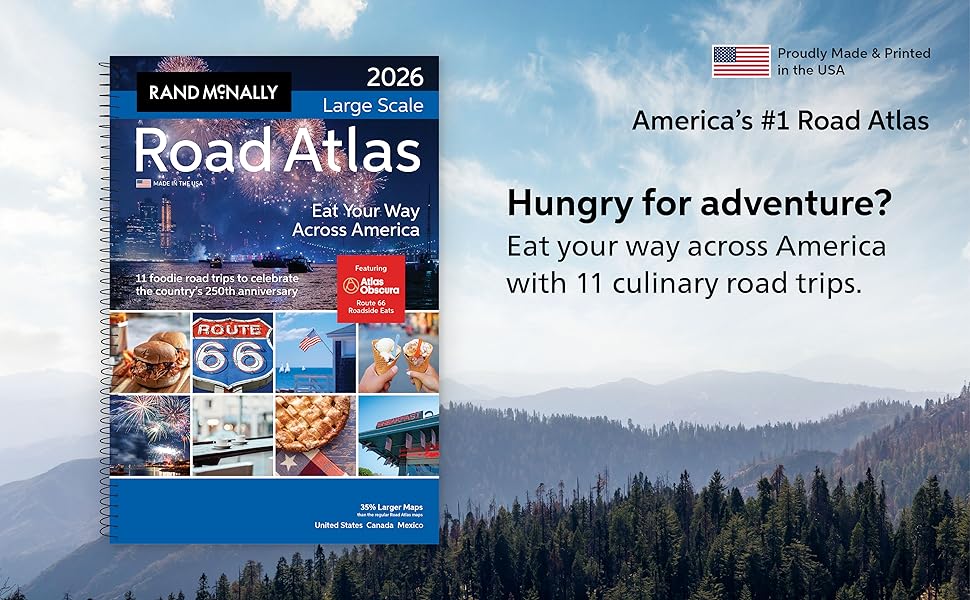
If having the most up to date and accurate maps developed by the #1 map company are important to you, then Rand McNally is your only choice. We have a 150+ year history of providing not just road and route guidance, but detailed information about the states, points of interest, historic sites, and much more. Another new feature offered by Rand McNally in our 2026 edition celebrating the USA’s 250th birthday and Route 66’s 100th anniversary, we’ve mapped out 11 extraordinary culinary road trips that explore the best of America’s regional cuisine.
We’ve even partnered with Atlas Obscura to ride shotgun, sharing their favorite off-the-beaten-path discoveries as well as their exclusive Route 66 Roadside Eats itinerary. Celebrity chefs such as Stephanie Izard, Aaron Franklin and more also have shared their “Chef’s Day Off” itineraries packed with insider tips highlighting their favorite foods and places to eat for maximizing your experience in their city. Bottom line, we provide more for your dollar in planning your next journeys.
Why Choose Rand McNally Over the Competition?
Always Up-to-Date
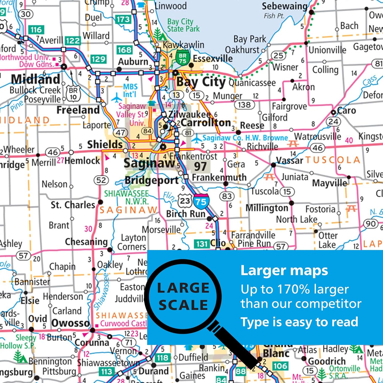
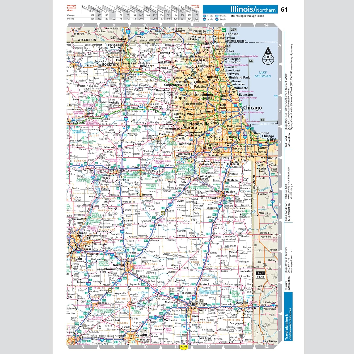
Updated annually – unlike competitors who update only 2-3 years or more.Larger, More Readable Maps
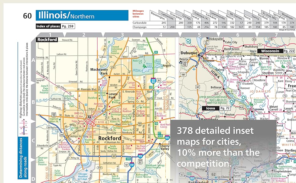
State maps are 35% larger than our regular Road Atlas and up to 170% larger than the competitor for easier navigation and planning.80% More Pages
304 pages vs. just 169 pages – offering easier to read maps with more map detail, more destinations, and more travel insight.
More City Inset Maps
378 detailed city insets vs. 345 – nearly 10% more.Brand-New Editorial Content
Explore 11 original culinary road trips in a dedicated 16-page guide, created to honor the country’s 250th anniversary – not a rerun of past content.Expertly Crafted Maps
Created by our in-house cartographic team in Chicago vs. outsourced by competitors.Made in the USA
Proudly made and printed in the United States, while theirs are printed in Canada.Easier on the Eyes
Clean white backgrounds and vibrant, user-friendly color palette vs. darker, less readable designs.Page Locator Map
Quick and easy access to the map you need.
Travel Planning Information
Tourism, construction, and toll info for each U.S. state and Canadian province.
Product Details
ISBN: 0528029290
UPC: 070609029290
EAN: 9780528029295
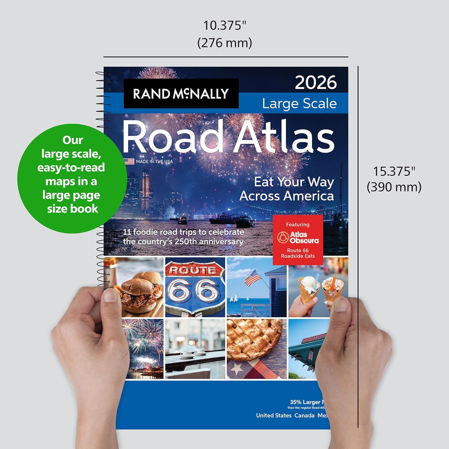
Dimensions: 10 3/8 x 15 3/8
Page Count: 304
Paperback
Spiral Binding
SRP: $ 32.99
From the Publisher
2026 Rand McNally Large Scale Road Atlas


Publisher : Rand McNally
Publication date : April 14, 2025
Edition : Annual
Language : English
Print length : 304 pages
ISBN-10 : 0528029290
ISBN-13 : 978-0528029295
Item Weight : 2.74 pounds
Dimensions : 10.8 x 0.8 x 15.2 inches
Best Sellers Rank: #427 in Books (See Top 100 in Books) #1 in United States Atlases & Maps (Books)
Customer Reviews: 4.7 4.7 out of 5 stars 1,117 ratings var dpAcrHasRegisteredArcLinkClickAction; P.when(‘A’, ‘ready’).execute(function(A) { if (dpAcrHasRegisteredArcLinkClickAction !== true) { dpAcrHasRegisteredArcLinkClickAction = true; A.declarative( ‘acrLink-click-metrics’, ‘click’, { “allowLinkDefault”: true }, function (event) { if (window.ue) { ue.count(“acrLinkClickCount”, (ue.count(“acrLinkClickCount”) || 0) + 1); } } ); } }); P.when(‘A’, ‘cf’).execute(function(A) { A.declarative(‘acrStarsLink-click-metrics’, ‘click’, { “allowLinkDefault” : true }, function(event){ if(window.ue) { ue.count(“acrStarsLinkWithPopoverClickCount”, (ue.count(“acrStarsLinkWithPopoverClickCount”) || 0) + 1); } }); });
11 reviews for Rand McNally Road Atlas Large Scale 2026: United States, Canada, Mexico (Rand McNally Large Scale Road Atlas USA)
Add a review
$30.75
michele simpson –
Perfect Gift & Excellent Reference
I purchased the Rand McNally Large Scale Road Atlas 2026 as a gift for my dad, and it was a big hit. The maps are clear, detailed, and very easy to read, which makes it especially helpful for planning trips or just browsing routes the old-fashioned way.Beyond the maps themselves, it includes plenty of useful travel information and points of interest, which add real value. My dad has already commented on how much easier it is to follow compared to smaller atlases or digital apps. There’s something about flipping through the pages that feels reliable and timeless.This is a high-quality, thoughtfully organized atlas that’s great for road trips across the U.S., Canada, and Mexico. Highly recommended for anyone who still loves having a physical map in hand.
Mario Maiorano –
This ROAD ATLAS it GREAT!
EXCELLENT ATLAS super LARGE DETAILS….Best thing to have on a road trip…navigation is GREAT but it is nice to have something that you can rely on when you have NO CONNECTION between your car connection and the space satellite…even if you have the BEST NAV money can buy, of course this excludes a satellite phone…I speak from experience.
Amazon Customer –
GREAT, GREAT, GREAT map! Love the larger print and ease of use when ‘net drops on the road.
I love using paper maps when we travel. You think, with wi-fi and internet everywhere, that you don’t need them, because th ‘net DOES HAVE PROBLEMS that you can’t fix while driving. I’ve had to go to Ohio twice this year (almost 1,000 miles one way), and I am the one who scopes out the obstacles and road changes while partner drives, and the interstates are changing routes everywhere with all the construction. I wouldn’t go on a trip without a paper map book anymore. I was using one from 2016 before I found this one. Not a trucker, so I didn’t need the truck one, but this one is GREAT! Please tell the company not to quit making paper maps with larger print! There ARE people who use them, and they need the up-size!
Mapydoo –
Great US Road Atlas but it is MUCH BIGGER than a breadbox!
It is easy to read, features large print, and provides a wealth of information. I enjoy examining maps during our travels, but I found this atlas to be too large for my needs. I should have checked the dimensions before placing my order. Additionally, the Canadian content is not very detailed, which was disappointing.
Just J –
Great atlas!
I bought this product before I took a road trip from the Midwest to the west coast. I hadn’t actually used one in a couple of decades. The maps were easy to read and had closeups of major cities. I like that it is spiral bound, which makes it easier to use. Overall a great product!
George wise –
Maps of all the U.S. states.
Nice book of maps, large size, easy to read. I like to look at roads that don’t show up on the gps, it’s fun exploring places that are out of the way.
Tom Hockman –
Rand/McNally Atlas Gets It Right
This was extremely useful on a recent 3200 mile road trip. The spinal binding makes it more useful to view a page without a binding trying to close the book. City details also help besides the state pages. It also lists the Gulf of Mexico by its proper name.
Kindle Customer –
I enjoy it
It’s great. Easy read and covers the subject very well…
Colin Patterson –
An oldie and still the best for long distance driving
Conny –
Nice easy reading
Diane –
Love the atlas.